


South Dakota
Photography by John Frim and Monica Frim
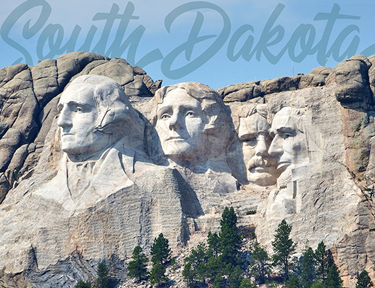
Their granite gazes follow the road as it winds among the mounds and hills of the highest mountains east of the Rockies. We could see them appearing, then disappearing in the folds of the landscape, four of America’s finest presidents, their 60-foot-tall faces taking pride of place in the Black Hills that dominate the western edge of South Dakota.
Known as the “Shrine of Democracy,” Mount Rushmore is a tribute to the presidents that master sculptor Gutzon Borglum considered most representational of the important junctures in American history: George Washington laid the foundation of American democracy, Thomas Jefferson signed the Declaration of Independence and doubled the size of the United States when he purchased the Louisiana Territory from France, Theodore Roosevelt upheld the rights of the common man against large corporate monopolies and negotiated the construction of the Panama Canal, and Abraham Lincoln stood for the integrity and preservation of the United States as a whole against slavery. But Mount Rushmore is more than a metaphor for the birth, growth, development and resilience of a country. With an estimated lifespan of 7 million years, the monument also represents physical endurance.
It’s been the inspiration of many sculptures, but the grandest will also be the world’s largest. A mere 17.8 miles away on another mountain, this monument has been in the carving since 1948. And still the end is pending. But oh, when that day comes, the figure of Crazy Horse riding his steed, one arm outstretched, index finger pointing forward, will tower eight times higher than the faces on Mount Rushmore and be visible for miles from all angles.
The reasons for the slow progress are historically, culturally, operatively and financially complicated, and outside the scope of this article. Suffice it to say that Polish-American sculptor Korcaz Ziolkowski originally estimated the entire project to take 30 years and with no funding from the government. Now 73 years after the first dynamite blast, only the 90-foot-tall head of the native war hero has been completed. Ziolkowski’s children, who took over the project after the sculptor’s death, still refuse government assistance, (which has occasionally been offered) relying instead on admission fees and donations. Hmm… if the Crazy Horse Memorial is projected to last at least as long as Mount Rushmore, they’ll have a few million years to drum up the funds.
Geologically, South Dakota is split by the Missouri River into two very different terrains: the ruggedly beautiful western section that features the precipitous outcrops of the Black Hills and Badlands, and the eastern agricultural prairies where rustic towns speckle the grasslands like pecans on pancakes and beauty is more subtle. To truly appreciate the shift in landscapes, one really needs to drive through both rolling prairies and ruggedly ridged mountains where the scenic routes and byways are among the highest rated in the country.
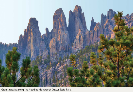
One of the most striking routes is the Peter Norbeck Scenic Byway which joins with two of the Black Hills’ most hair-raising roads: the 17-mile-long Iron Mountain Road that links Mount Rushmore to Custer State Park, and the 14-mile-long Needles Highway that winds and dips among the granite spires known as The Needles. With switchbacks, one-lane tunnels, and pigtail bridges that loop 360 degrees over their own road, these routes make for some pretty terrifying drives—especially if you negligently try taking a motorhome that won’t fit through the tunnels. The Needle’s Eye Tunnel, for instance, is only 8’4” wide and 11’3’’ tall. Other tunnels are only a few inches roomier. Motorists are warned of the tunnel sizes well in advance but occasionally a heedless (or reckless) driver of a too large vehicle will find herself stuck on the narrow winding road with no way forward or backwards, unable to fit through an impending tunnel. Don’t ask how I know.
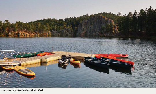
Custer State Park is one of the largest state parks in the United States, taking up 71,000 acres of the western Black Hills National State Forest. Ponderosa pines and spruce make the hills appear black from a distance, but a closer inspection reveals various shades of green, especially in areas of birch and aspen, and muted hues of pink, gold, grey and tan that deepen as the day progresses and the shadows grow longer.
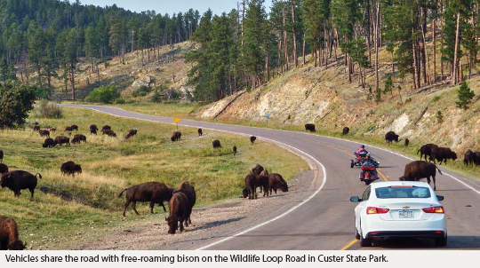
The northern third of the park is dotted with lakes, lodges, campgrounds and the park’s most riveting geological protrusions: the sky-piercing Needles and Black Elk Peak, the highest point east of the Rockies. Southbound, the rocky spires shrink into hills and prairies where some 1,400 bison roam, pronghorn frolic, and feral burros beg for handouts from passing motorists. Sightings also include white-tailed deer, mule deer and prairie dogs and, less frequently, big horn sheep, coyotes and mountain lions. It’s not unusual for motorists to be stuck in a bison jam on the Wildlife Loop Road that circles the grasslands. Motorcyclists, in particular, need to be extra watchful—bison can mistake the roar of a motorcycle for a mating call.
If you think the Black Hills positively teem with picturesque sights, wait until you see what’s underneath them. Scattered throughout the hills, subterranean caves with labyrinthine tunnels and rooms boast some of the most exquisite calcite formations on the planet. Jewel Cave National Monument, with more than 175 miles of mapped underground passages, and Wind Cave National Park, with scenic trails both above and below ground, are rated among the largest cave systems in the world. Wind Cave National Park is also home to bison and many of the other furry four-footed critters of Custer State Park. If you’ve missed them in one park, you’re bound to see them in the other.
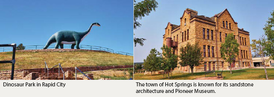
Tiny Black Hills towns like Keystone, Hill City, Custer and Hot Springs, all with restaurants, specialty shops and distinctive museums, provide close and easy access to Custer State Park. An old 1880 steam locomotive links the timber town of Hill City with the old gold mining town of Keystone, which is also the closest town to Mount Rushmore (three miles away). Custer is generally considered to be the oldest town in the Black Hills and Hot Springs, home to the largest concentration of mammoth remains in the world. Excavations are ongoing and visitors can tour the active dig site at Mammoth Site and Museum.
For travelers who prefer something a little more urban, Rapid City on the eastern edge of the Black Hills is the second largest city in South Dakota, and the major gateway to attractions east and west. Historic buildings line the downtown streets and bronze statues of the presidents dominate street corners in a nod to Mount Rushmore. Above the city, Dinosaur Park teems with life-size replicas of dinosaurs in playful parody of real dinosaur footprints found nearby and in other parts of the state. Sure the park is kitschy, old-fashioned and just a bit puerile but the same cannot be said of the view. It may not stretch the full 100 miles touted in the brochures, but if you look to the east you can see the Badlands 60 miles away.
Unlike the monumental granite spires and outcroppings of the Black Hills, the rock formation of the Badlands are sedimentary layers of sandstone, limestone, silt, mud, clay, volcanic ash and shale that’s been pressed together and carved into fantastical shapes by wind and torrential downpours. The result is an otherworldly moonscape banded with waves of pink, ivory, khaki, and gold that glow especially intense in the early mornings and evenings. At those times the rocky terrain looms like a rainbow stretched over the semi-arid grasslands that surround the Badlands National Park.
A 31-mile scenic byway known as the Badlands Loop takes motorists past ragged ridgelines, eroded buttes and pinnacles to nearly 30 breathtaking overlooks and pullouts. You can drive the entire loop in less than an hour or in fits and starts that can last all day with breaks for hiking some of the trails and savoring the scenery. Even if you’re not a hiker you’ll want to step out of your vehicle. Some of the best views and lookouts are only a five-minute walk from the parking spots.
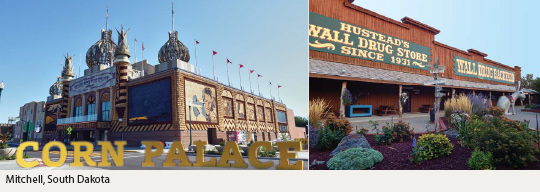
Eight miles north of the Badlands, the drugstore that made the tiny town of Wall world famous started out simply enough—with a gimmick that had parched passers-by on the empty prairie flocking to the store for its most comforting commodity, free ice-water. The store also offered coffee for five cents. Of course that was in 1931, before Wall Drug store cornered the market on kitsch and funk and ice wasn’t as readily available as it is now. Today’s tourist frenzy goes more for outlandish caricatures, camp and kink, although there’s also a travelers’ chapel that somehow belies the mythical jackalopes, gaudy ornaments and animatronic Tyrannosaurus Rex that roars to life every 15 minutes in a blaze of lights and chilling sound effects.
Admittedly, Wall Drug is the paragon of roadside kitsch, but a well-loved one even by those who would normally avoid anything even remotely resembling a trippy tourist pitstop. So why are these skeptics so eager to pull in at the 80-foot concrete statue of the Apatosaurus that greets visitors outside, and then venture inside? Maybe because they’ve been seeing the Wall name at seemingly every mile for the last 500 miles, regardless of which direction they’re coming from. Or maybe they want to see if coffee still costs only five cents. (It does.) In any case the fact remains that an American road trip just would not be an American road trip without roadside attractions.
South Dakota is like that—full of outlandish attractions that break up the surrounding flatlands with whimsy and weirdness as if to make up for the grassy plains’ lack of geological hulk. It’s almost as if the grasslands are telling the hills, so you have Rushmore and Crazy Horse and Custer and Needles and Badlands and caves, but just look at our giants: gaudy dinosaurs in every second town; creepy metal sculptures in Porter Sculpture Park near Montrose that include a metal sculpture of a Bull’s head that is actually the size of Mount Rushmore; a 20-by-40-foot-long sculpture of a pheasant that is, presumably, the largest bird sculpture in the world, in Huron; a 12-foot high prairie dog at the Ranch Store near Badlands National Park; and a corn palace in Mitchell whose entire façade is redecorated each year with murals made entirely out of corn and other local grains and grasses. There’s something about a flat landscape that begs for gimmickry.
Still, you have to drive a good mile from the border with neighboring states before this tendency hits you. Near the Wyoming border, Belle Fourche’s most eccentric claim is simply a tasteful granite monument that commemorates the geographic center of the United States. (The true geographic spot is actually 20 miles north of Belle Fourche, so some liberties with placement were taken.)
Nearby the art center of Spearfish also eschews kitsch for culture and recreation. The town serves as gateway to Spearfish Canyon where towering limestone cliffs give way to cascades and waterfalls accessible via hiking trails among ponderosa pine, spruce and aspen trees. The Spearfish Canyon Scenic Byway runs along the canyon walls between Spearfish and the historic stage stop of Cheyenne Crossing 12 miles from the legendary Wild West town of Deadwood.
Deadwood got its start in the 1870s when gold was found in a gulch of dead trees (hence the name), and gamblers and gunslingers moved in for some payoff. These were the stomping grounds of people like Calamity Jane and Wild Bill Hickok. Their resting places on Mount Moriah overlooking the gulch are among today’s most visited attractions.
Below the Mount the town is still very much alive—bawdy and boisterous, with modern-day gamblers and risk-takers hoping to strike it rich in the town’s casinos. But if your penchants lean more toward history and culture, you can check out the architectural gems of the grand hotels and historic houses or relive the town’s lawless past in the area known as The Badlands with trademark saloons, brothels and gaming halls. Historical reenactments—from shootouts to musical shows to the “Capture of Jack McCall”—also take place daily on the downtown streets.
There’s no doubt that the tourist tracks cut deepest in the rockscapes and quirky towns of the Black Hills and Badlands, but it would be a shame to bypass two of South Dakota’s most atypical cities: Pierre, the second smallest state capitol, and Sioux Falls, the largest city in the state. Between them the Native American Scenic Biway follows the Missouri River for 100 miles through the heart of the Teton Lakota Nation to Chamberlain, then joins with the I-90, which carries you through Mitchell and corn country to Sioux Falls and into the State of Wisconsin. In Pierre, leafy streets and charming historic buildings surround the capitol building, which happens to be built from the same architectural blueprints as the one in Montana. Together with the early trading post of Fort Pierre on the west bank of the Missouri River, Pierre’s heritage attractions provide a tangible link to the early explorations that opened up the country.
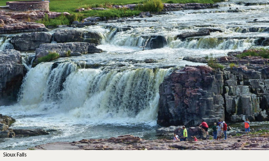
As a metropolis and state gateway Sioux Falls gets undeserved short shrift. Sure the pink quartzite formations that cradle the Falls of the Big Sioux River aren’t in the same league as the granite carvings at the other end of the state, but who’s comparing? The Falls themselves are magnificent, surrounded by parklands and the remains of some of the city’s earliest buildings. Their foundations offer vantage points for enjoying the natural surroundings with the best vistas from the five-story observation tower at the Visitor Information Center.
The city also boasts a vibrant art scene. Towering 70 feet above the Big Sioux River River, the stainless steel Arc of Dreams, is the city’s most prominent art installation. It’s taken some of the heat off the full-size bronze replica Statue of David that was once Sioux Falls’ most controversial sculpture and led to some humorous cover-ups involving fig leaves and other unauthorized dressings. Nowadays the downtown galleries and modern sculptures displayed year round on the art-and-sculpture trail known as SculptureWalk elicit more positive attention proving that, in art, the biggest city in South Dakota is a serious player.
It’s a strange thing when small towns go big and big towns go small but totally in keeping with the paradox that is South Dakota. You can stand face to face with presidents, gunslingers and goldseekers; pose for selfies at kitschy roadstops or meander mesmerized through blindingly beautiful rockscapes and man-made installations of art in one fell sweep. Take as many days—or weeks—as you can.
- Apartments, Housing, and Real Estate
- Automotive Sales & Leasing - Cars, SUVs & Trucks
- Clothing & Apparel
- Communications & Technology
- Concierge Services
- Contracting
- Dining & Entertainment
- Education
- Event Planning Services
- Financial Services
- Health & Beauty
- Home Furnishings
- Hotels & Accommodations
- Insurance
- Medical & Dental Services
- Office Services
- Property Management
- Security Services
- Shipping & Moving Services
- Specialty Services
- Travel & Transportation

info@diplomaticconnections.com
It is strictly prohibited and illegal to download, replicate, retransmit, reproduce, or otherwise use any items whatsoever on this website.