


Wild, Wide, Wonderful Wyoming
Photography by John Frim and Monica Frim
In pandemic times one’s thoughts tend to hover between memories of past trips and dreams of future adventures.
Confined as we’ve been to our own back yards, the itch to be anywhere but here is probably as common as a pair of worn-out shoes. But where to go? According to a survey by National Geographic and Morning Consult, Americans would feel safest traveling to wilderness areas such as state parks or to destinations they have either traveled to before and/or places that regularly host tourists.
Wyoming appears to be a shoo-in.
The entire state has fewer than 500,000 residents—less than the number of antelope that graze on its ubiquitous sagebrush. Admittedly it’s one of the harshest states in the Union, but with some of the most dramatic natural attractions found anywhere on this planet. The two most popular national parks, Yellowstone and Grand Teton, seasonally beef up Wyoming’s meager population with more than four million visitors to Yellowstone and 3.4 million to Grand Teton a year (2019 statistics).
But to truly appreciate Wyoming’s Wild West culture, one needs to follow the roads that grew out of the ancient trails used by Native Americans, early fur trappers, traders, homesteaders and the military administrators who established and ran the early forts and outposts. They crisscross the state over plains and deserts, follow rivers that cut through precipitous canyons and over forested mountains, and lead to diminutive cities that still look as if they belonged to a former era of law makers and breakers. While Wyoming may not be as sophisticated as the coastal states, it rightfully claims bragging rights to many firsts: first national park in the world (Yellowstone, designated by President Ulysses S. Grant in 1872, eighteen years before Wyoming became a state), first national monument in the world (Devil’s Tower, designated by Teddy Roosevelt in 1906), first national forest (Shoshone, designated in 1891), first state to grant women the right to vote (in 1869), and first state to have a female governor (Nellie Tayloe Ross from 1925 to 1927).
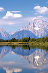
Still, pockets of glamor poke through the state’s cowboy veneer in places like Jackson Hole, where celebrities such as Brad Pitt, Sandra Bullock and Julia Louis-Dreyfus maintain second homes. Known for its breathtaking natural setting between the Grand Tetons and Gros Ventres mountains, the Jackson Hole valley is the perfect gateway to Grand Teton National Park and the scenic sprawl beyond.
Jackson and Grand Teton National Park
In Grand Teton National Park, jagged peaks and glacial lakes were born of a violent past that lasted millions of years. As forceful earthquakes shook the earth, phenomenal heaving and folding created the Grand Teton Range on one side of the fault line and the flat valley floor of Jackson Hole on the other. Over millions of years, glaciers, wind and water further eroded the landscape, carving canyons, hollowing out basins, and tumbling rocks into moraines. But the glistening glacial lakes (Jackson Lake is deepest at 400 feet) and knife-edged mountains (Mount Teton is tallest at 13,770 feet above sea level) that lure millions of hikers, climbers, boaters, photographers and general travelers to scenes of immense beauty and bucolic contemplation are not quite as still as they seem. The ground still moves stealthily as, bit by bit, the Jackson Hole Valley continues to sink while the Teton Range rises. The distance from the highest peak to the deepest hole is more than 30,000 feet—higher than Mount Everest.
At the foot of the mountains, Jackson is a touristy portal to the Teton Range, National Elk Refuge and Yellowstone National Park. It’s an oasis of rustic shops and galleries and a town square framed by elk-horn arches that emulates the spirit of the Wild West with street theater performances and historic wooden buildings. For people who need a kitschy fix or maybe just the comforts of consumer goods and services, Jackson makes for a perfect stop.
Yellowstone National Park
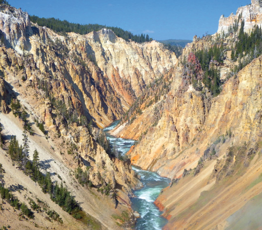
Only 31 miles north of Grand Teton National Park, Yellowstone National Park (photos on pages 20 & 23) delivers a fiery counterpunch to the Grand Tetons’ glacial footprint. Forged millions of years ago by a raging inferno that still roils deep within the bowels of the earth, Yellowstone is still an active underground volcano heating up some 500 geysers (roughly half the geysers in the world) and 10,000 hydrothermal features. As geysers erupt—some continuously, others unpredictably, and still others at quasi-regular intervals—mudpots, hot springs and fumaroles seethe, bubble and hiss in distinctive thermal areas known as basins. Hottest, most acidic and most active is the Norris Geyser Basin, but Midway Geyser Basin is arguably the most dazzling. Its Grand Prismatic Spring is the largest and one of the most colorful. The brilliant red, orange, green and yellow colorations that encircle this and other thermal springs owe their intense hues to heat-loving microorganisms called thermophiles that somehow thrive in extreme conditions. While Old Faithful is one of Yellowstone’s star attractions, it is by no means the largest geyser. What it does have going for it is frequency and predictability, hence its name.
But Yellowstone is not just about geysers and colorful springs. Waterfalls roar throughout the park, from the tallest—the 305-foot-high Lower Yellowstone Falls that tumble between the sulfur-caked cliffs that inspired the Yellowstone name—to the widest, the 250-foot-wide foaming fringe of Cave Falls on the Fall River in Yellowstone’s southwestern corner. There are at least 45 named falls and cascades in the park, with many more smaller unnamed ones, and new ones still being discovered.
Roads and hiking trails wind and twist among cliffs and mountains with pullouts for the views, dip into broad valleys dotted with wildflowers or meander over sagebrush-covered plains roamed by bison, elk and coyotes. Yellowstone is truly a wildlife haven, and hikers and sightseers could encounter black bears, grizzly bears, lynx or foxes in the forests, or bobcats and cougars in rocky places. It’s obligatory for two-legged beasts to be watchful and stay on the boardwalks or trails. Bison have right of way.
Cody and Shoshone National Forest
Known as the Buffalo Bill Center of the West, Cody is connected to Yellowstone National Park by the Buffalo Bill Cody Scenic Highway, a route that follows the Shoshone River and the rugged tors and cliffs of the Absaroka Range. It cuts through the Shoshone National Forest and the sprawling ranch community of Wapiti to the Buffalo Bill Reservoir and Dam. At its completion in 1910 it was deemed the tallest concrete dam in the world. The dam is still an impressive piece of engineering with a complicated construction history owing to its difficult cliff-side perch. Next to the dam, Wyoming’s longest tunnel, the Shoshone Canyon Tunnel, and two smaller tunnels lead to an area of sulfuric fumaroles and hot springs known as Colter’s Hell after John Colter who gave the Shoshone River here its erstwhile name of Stinking Waters. An early member of the Lewis and Clark expedition, Colter also did his own exploring and reputedly became the first white man to enter the region of Yellowstone Park in 1807.
Colter’s Hell sits on the outskirts of Cody City, founded by Buffalo Bill Cody in 1896. The original town site was laid out near DeMaris Hot Springs but lasted only about two years. The town’s few buildings were packed up and hauled two miles east and renamed simply Cody. Today the 2,500-foot-long Colter’s Hell Interpretive Trail loops over the old site between the Stampede Rodeo Grounds and the Old Trail Town—a collection of various historic log cabins, wagons and artifacts.
In the heart of the city, Wild West recreations take the form of street theater with staged gunfights by actors portraying historical characters in front of the historic Irma Hotel (named for Buffalo Bill’s youngest daughter). Inside, the hotel restaurant’s cherry wood bar was a gift to Bill Cody from Queen Victoria of England.
Cody is rife with Buffalo Bill memorabilia in the form of special exhibitions, statues, and museums such as the Buffalo Bill Center, which actually comprises five museums, though not all are related to Buffalo Bill. But for a different aspect of western culture, Cody Nite Rodeo bills itself as the roughest nightly rodeos in the West, and Cody as the “Rodeo Capital of the World.”
Touristy yes, but it’s what one would expect of the largest city in the Bighorn Basin.
Bighorn Basin: Meeteetse, Thermopolis and Hot Springs State Park
North of Cody, the Japanese American Confinement Center at Heart Mountain offers a glimpse of the remains of the former internment camp with memorial stones and other markers along walking trails and overlooks. Beyond the Center rolling lands of dry grasses and scruffy bushes dot a lonely landscape of badlands known as the Bighorn Basin. Fossils abound in this barren landscape with more dinosaur footprints than human ones, and ancient petroglyphs decorate sandstone cliffs and outcrops that stand up surprisingly well to winds and seasonal temperature extremes. Here and there quaint museum towns look like they’ve been plunked into the wilderness from another era. They offer a respite of history and culture in an area woefully devoid of creature comforts.
Thirty miles south of Cody is Meeteetse, a tiny hospitable town of some 300 people that’s barely a dust mote on a map, but brimming with relics of western history. Wooden watering troughs, hitching rails, wooden sidewalks and excellent museums with no admission fee complement old buildings with connections to Butch Cassidy and wealthy cattle barons.
Between Meeteetse and the spa town of Thermopolis, the sacred site of Legend Rock Petroglyphs is a leap back 10,000 years in history. Located about eight miles west of Highway 120, the last three miles consist of a rough gravel road that truly evoke a time-traveling feeling. But what a reward at the end! Cliff walls decorated with more than 92 petroglyph “panels” and 300 figures of mythical horned creatures, thunderbirds and elk are set along an interpretive trail. Just watch where you step and listen for buzzing: rattlesnakes love these rocks!
Farther south the dramatic hills and sandstone canyons nestle the stunningly pretty town of Thermopolis, which is, curiously, part of Hot Springs State Park. Here millions of gallons of hot water gush out of the ground daily, channeled into swimming pools, soaking pools, steam rooms and waterslides. Over the years drippings of minerals from the spring water have formed the colorful travertine Rainbow Terraces that look like frozen waterfalls along the Bighorn River. Since legendary times, the hot mineral springs have been known for their healing powers. Remarkably, they’ve remained an affordable luxury with free admission to a government-run bathhouse and reasonable admission costs to the adjacent TeePee Spa and Star Plunge Water Park.
Thermopolis is also the portal to the Wind River Canyon where one of the most scenic drives in Wyoming, the Wind River Canyon Scenic Byway, winds among spectacular cliffs and rock walls. After 14 miles, it culminates at the Boysen Reservoir, a popular sporting area in Boysen State Park.
Bighorn Mountains
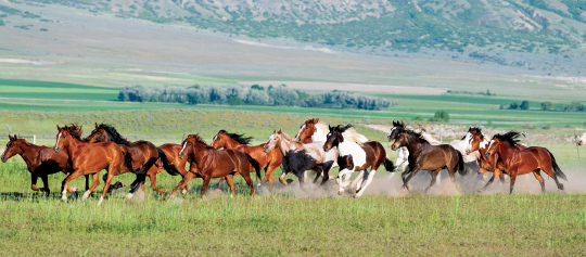
Surrounded by six mountain ranges, the Bighorn Basin covers an area that’s roughly 150 miles long and 80 miles wide. At its northeastern terminus its namesake mountains loom over the basin, studded with the pine, spruce and fir trees of the Bighorn National Forest. Scenic roads and hiking trails crisscross the Bighorn Mountains and lead to some of the most ruggedly beautiful lookouts in the country. A favorite is Devil Canyon Lookout in the Bighorn Canyon National Recreational Area, an elongated parcel of scenic glory shared by Wyoming and Montana (the Lookout is actually three miles into Montana). Along with the dizzying views from the Canyon ridges into the winding gorge of the Bighorn River, it’s sometimes possible to spot wild horses, bighorn sheep and mountain goats straggling on the canyon walls.
All around, a steep and craggy world of beautiful tors and sacred Native American circles stipple the Bighorn Mountains culminating at Bighorn Medicine Wheel atop Medicine Mountain east of Bighorn Lake. Designated a National Historic Landmark in 1970, Medicine Wheel is a mysterious circle of stones 80 feet in diameter with 28 lines or spokes radiating from its center to the outer rim. It is still a sacred place of ritual for Native Americans but can be visited by anyone willing to brave the steep gravel road that leads to a parking lot, then walk the 1 ½-mile trail to the circle.
Devils Tower Monument
Rising majestically where the forests of northeastern Wyoming meet the central prairie lands and the Belle Fourche River carves the sandstone into labyrinthine gorges, Devils Tower Monument stands out like a corn dog stuck in a pizza. You can see it for miles. Every year more than 5,000 rock climbers scale the iconic butte where hundreds of parallel cracks on hexagonal columns provide finger- and foot-holds. For non-climbers, three walking trails loop around the base of the monument and provide views that show how the rock changes with its orientation: eroded columns on the south side, a smoother north side, and fallen broken columns on the west. It takes about 45 minutes to walk the shortest loop around the base through a forest of ponderosa pine and scree. Look out for poison ivy and don’t pet the rattlesnakes.
- Apartments, Housing, and Real Estate
- Automotive Sales & Leasing - Cars, SUVs & Trucks
- Clothing & Apparel
- Communications & Technology
- Concierge Services
- Contracting
- Dining & Entertainment
- Education
- Event Planning Services
- Financial Services
- Health & Beauty
- Home Furnishings
- Hotels & Accommodations
- Insurance
- Medical & Dental Services
- Office Services
- Property Management
- Security Services
- Shipping & Moving Services
- Specialty Services
- Travel & Transportation

info@diplomaticconnections.com
It is strictly prohibited and illegal to download, replicate, retransmit, reproduce, or otherwise use any items whatsoever on this website.