


North Carolina's Outer Banks:
Photography by John Frim and Monica Frim
Diplomatic Connections is now dedicating a section of each publication to national and international destinations. We are continuously asked for more information about different places to travel to. For this installment, join Monica Frim on her travels to North Carolina's Outer Banks, including Hatteras, Roanoke Island, Corolla, Duck, Kitty Hawk, Nag's Head and Ocracoke Island — a journey of history, sun, sand, and great beauty.
It's a sheltered life here in Washington — sheltered, that is, in terms of geological upheavals. While snowstorms, earthquakes, hurricanes and tornadoes have been known to pound and shake the Potomac environs, their touch is but a debonair tap compared to the weightier pummelings of places farther-!ung. For Washington lies within a buffer zone that is cushioned from the violence of the Atlantic Ocean by a comma of land that dips between the Atlantic Ocean and Chesapeake Bay. You can cross it in 2½ hours by car, travelling through the states of Maryland and Delaware to Lewes, gateway to a tether of weather-whipped spits and islands with sand dunes and salt marshes that stretch along the Atlantic Ocean all the way to Florida.
Go farther south and the Outer Banks of North Carolina reveal an even wilder side. Here, there's beauty in nature's fury, and rapturous escape in history's ingenuous events. You can sap up storm-de#ant treasures, either alone on an empty beach or in a crowded resort town where boardwalks, piers, go-kart tracks and seaside restaurants lure the young and the young at heart with action-packed options. Kite boarding, kayaking, hiking, hang gliding, sur#ng, lighthouse climbing, bird watching, #shing, crabbing, diving, cruising, shelling, jetskiing, parasailing, swimming… the smorgasbord of activities is as endless as the grains of sand.
But as the song says, silence is golden and so are deserted beaches where feral horses roam and desert dunes shift along narrow strips of sand that constantly change shape and pro#le according to the whims of wind and water. Stand back and you can almost see geography in the making as the sand swivels from one pile to another dismantling old dunes and creating new ones. Sit back, do nothing and savor your inertia. An idle respite can do an antsy spirit good.
The paradox of America's Eastern Shore lies in its balance of crowded resorts and near-empty spaces. They are so close to each other that you can shift between frenzy and near comatose repose several times in a single day or savor an entire week in the environment of your choosing.
History, too, can be as close as you let it. Museums tell of shoals and shipwrecks (this is, after all, the watery playground of Blackbeard and other pirates), wars and watchtowers, #rst !ights and feral horses known as "bankers." These short and hardy creatures still roam the buffer strands, albeit in managed herds, their arrival on the islands as mysterious as the fate of the #rst English settlers who disappeared without a trace from the island of Roanoke well before Plymouth and the colonial triumvirate of Jamestown, Yorktown and Williamsburg took root as America's founding cities. In that sense, the #rst European settlers were not English adventurers, but four-footed grazers, likely of Spanish descent. Conjecture says the horses either swam to shore from shipwrecked Spanish galleons or were brought there as early as 1526 by the Spanish explorer Lucas Vázquez de Ayllón when he tried to establish a colony in South Carolina. Others have suggested that the horses were the only survivors of Sir Richard Grenville's failed attempt at a naval base in 1585 at the behest of Sir Walter Raleigh.
With 600 soldiers and would-be colonists, Grenville washed ashore at Roanoke Island and left Ralph Lane in charge while he (Grenville) returned to England for additional supplies. The natives and Europeans bonded in trade, then bickered and parted under most unfriendly terms after Lane killed the Secotan Indian Chief Wingina over a stolen cup. Lane skedaddled back to England on board Sir Francis Drake's ship with most of the settlers in tow mere days before Grenville's return with the promised supplies. The defection marked the end of Governor Lane's colonial career, though not the end of Sir Walter Raleigh's dream of colonization. In 1587, Raleigh tried again. He mustered 117 men, women and children under the governance of John White and sent them off to establish a permanent colony on the Chesapeake Bay. They made it as far as Roanoke Island and within three years disappeared without a trace leaving only the word "CROATOAN" carved into a pole and the letters "CRO" carved into a tree. Their fate has been the subject of much conjecture. Did they !ee hunger and/or hostile Indians for the nearby Island of Croatoan (now Hatteras)? Nothing has been found. Were they massacred by Indians bent on revenge for the killing of their chief years earlier? There is no evidence. Did they starve to death? Intermarry with native peoples? Get taken as slaves by Indian traders? Succumb to Spanish raids? Historians remain baf!ed to this day.
Today, on the northern tip of Roanoke Island, clues to the Lost Colony unfold within the Fort Raleigh National Historic Site like a murder mystery without a resolution. While you never get to the "who dunnit" part, you can tease out the background on a stroll past a recreated earthen fort and from replicas of John White's water color sketches in the Elizabethan room of the visitor center. Pictures of Indians in soft pastel-colored robes or loincloths and mat-roofed domes of village homes surrounded by a circular forti#cation of poles testify to the mores of Indian tribes such as the Secotans, a people who disappeared within 200 years of meeting their #rst European foils. Canoeists stand punting with long paddles through shallows while #shermen spear #sh with poles longer than the men are tall. Eastern box turtles, with orange and green carapaces and crabs in muted pinks and blues serve as reminders of the agelessness of !ora and fauna from a pre-Kodak time when trip mementoes took the form of brush strokes not cameras. For John White was not only the leader of the failed colony of the "Cittie of Ralegh" but a talented artist and mapmaker. Much of what we know about the colony comes from his paintings and writings. He sailed back to England in 1587 to seek fresh supplies but could not return to Virginia, as the area was then called, until three years later. In the meantime the colonists vanished, including White's granddaughter, Virginia Dare, the #rst child of English parents born in the New World. Ironically, the tiny infant of unknown fate achieved lasting fame as a tool for imaginative branding as clever scribes and marketing types labeled their liquors, sodas and vanilla extracts "Virginia Dare." She has been the subject of books, #lms, animations and songs, and honored on postage stamps and in the names of many places in the southern United States. A sculptor's vision in Carrara marble of Virginia Dare as an adult, had she survived whatever trauma befell the early settlement on Roanoke Island, stands in the Elizabethan Gardens next to the Fort Raleigh National Historic Site.
But the greatest homage to the short-lived colony and its intrepid settlers comes in the form of the longest-running outdoor historical drama in the United States. In an amphitheater overlooking Albemarle Sound, playwright Paul Green's symphonic play, The Lost Colony, has been cutting through the soft summer surge of the Sound since 1937 in a rousing pageant of music and action that sweeps from Queen Elizabeth's sophisticated court to a sylvan baptism to a #ery Indian raid.
Elsewhere on the island, Civil War memorials attract devotees of military memorabilia. Several forts look over Croatan Sound on the northwestern part of the island while Freedom Trail winds through woods to a memorial marker that commemorates the freed and runaway slaves who found a safe haven on the island.
A short hop east, the Washington Baum Bridge connects Roanoke Island to the 120-mile stretch of surf and sand that stretches from Corolla just south of the Virginia- North Carolina border to Ocracoke, an island of dunes and marshes accessible only by ferry. Houses on stilts in towns with whimsical place names like Duck, Kitty Hawk, Nag's Head and Whalebone Junction are strung along a coastline that is somehow wide enough and stable enough to support an array of shops, restaurants and oiled bodies. At Nag's Head there's even a hospital. The towns' names are couched in obscurity with various stories to explain their origins. In one version Nag's Head, refers to the practice of "wreckers" hanging lights on mules heads' to lead ships onto the shoals for looting. Many ships transported barrels of rum, known as "Kill Devil" in the parlance of the day, giving rise to the name Kill Devil Hills. Apparently the "wreckers" would hide their pilfered rum in the sand dunes of the area where Orville and Wilbur Wright tested their gliders then took wing over !at ground in the #rst powered aircraft for an unprecedented 12-second-!ight. By their fourth try they managed to stay aloft for 59 seconds and a distance of 852 feet. Sixty-five years later Neil Armstrong walked on the moon. Today a 60-foot granite monument in homage to the Wright brothers crowns Kill Devil Hill, but it's the !imsy "Flyer" housed in the rotunda of the visitor center below that's most likely to catch your eye, possibly because the mannequin resembling a supine Orville steering the plane from atop the lower wing sports dapper plaid pants with matching hat, a vest and a tie.
Today's hang gliders dress less formally and their preferred roaming skies are above the East's highest sand dunes at Jockey Ridge. Here are also the operational grounds of the world's largest hang gliding school. But you don't need to soar through the air to enjoy the solitude of the pale blue skies or the quiet whisper of the wind. You can watch hang gliders from below or meander through the 400-acre grounds of Jockey Ridge State Park on self-guided nature trails that penetrate a variety of environments from wetlands to grassy dunes. Daylight affords the best views of the colorful human birds that, as one bystander commented, "run like the devil, then soar like angels" into what surely must be freedom, serenity and solitude. But early morning is the best time to catch the prints of foxes, deer, rabbits and lizards in the sand. Look closely at the sand grains, amber as the sunrise, and you'll see a scrollwork of tiny depressions, evidence of wingtips of birds and insects having taken !ight from the sand. By evening, the day's traf#c of hikers scrambling up and down the soft dunes will have ground the delicate reliefs of animal prints and the wavy patterns of shifting sands into a giant playground of overlapping pits and pockets.
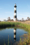
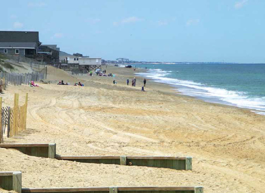
Heading south, the Cape Hatteras National Seashore is a refuge of dunes, marshes and woodlands with no clear demarcation point between land and sea. Dubbed, "The Graveyard of the Atlantic," more than 600 shipwrecks have found watery resting places as victims of shoals, storms, subterfuge and war. In this setting, lighthouses once played an important role in guiding sailors to safety. Today, most serve as museums or photo-worthy foregrounds in picturesque settings. Some, such as the black and white barber pole-striped Cape Hatteras Lighthouse, are open to climbers. It is the tallest brick lighthouse in America, sturdily built in 1870 at a respectable 1500 feet from shore, but without pilings. For who of that era could have imagined that, at that distance from the shore, the lighthouse would someday be lapped by water and at risk of falling into the ocean? But the power of the Atlantic is such that it can roll up the seashore and deposit it elsewhere. Like Sisyphus pushing the rock, the Atlantic pounded the shore and gnawed at the lighthouse base — to the tune of $3 million in repairs until the government decided it might be better to shell out an additional $10 million and move the lighthouse out of harm's way once and for all. Since 1999, the lighthouse proudly stands 2,900 feet farther inland, its doors and stairs open to visitors. The foundation stones of the original site were left at the edge of the sea when the lighthouse was moved. They are engraved with the keepers' names.
Ocracoke Island is wild and thin and empty — a country bumpkin at the southern tip of the Cape Hatteras National Seashore. A free car ferry provides access from Hatteras Island. There are no restaurants, amusement parks or tourist amenities until you reach the end of the 15-mile road that bisects the island like a straight strand of black licorice. On one side, marshy greens full of bonsai-like oaks and shimmering salt grasses dissolve into the !at blue waters of Pamlico Sound. On the other, a dark blue ocean rolls with white-fringed gusto over sandy shores shifting, changing, kneading the land into strips of doughy dunes that rise and fall with the moods of the weather. It's the best place for Outer Bank souvenirs if your idea of good souvenirs means seashells and !otsam scavenged from beaches where you can walk for miles without meeting a single soul.
Historically, Ocracoke's most famous residents were Blackbeard and "bankers," monikers for, respectively, the pirate Edward Teach, and the feral horses, sometimes called ponies for their short stature. For a while the townspeople tolerated them both. Although Blackbeard terrorized merchants in the Atlantic Ocean and the Caribbean Sea, raiding their ships and killing those who protested, the townspeople enjoyed the bene#ts of his labors, which Blackbeard sold to them at a fraction of the cost of legitimate imports. By contrast the "wild" horses were as gentle as the breezes off Pamlico Sound. Their worst traits involved an occasional intrusion into a vegetable garden or a rare stampede through town. In the mid-twentieth century they even joined the Okracoke Boy Scout troop, which was the only troop on horseback at that time.
Nevertheless, the ponies ended up in the care of the National Park Service, which now owns the entire island. They are corralled halfway along the island's only road in Wild Pony Pens, their free-roaming days over. Proponents of corralling point out that bankers have been brought back from the verge of extinction and receive excellent, if regimented, care with controlled breeding programs and safeguards from the traf#c of Highway 12. Opponents argue that there has never been a need to isolate them.
Blackbeard was #nally murdered at Ocracoke Inlet in 1718, his head cut off and suspended from a Royal Navy sloop as a warning to other pirates. According to legend, his headless body, thrown overboard, swam around the ship several times before sinking. Today superstitious villagers swear that on a clear day they can still see his body rising out of the depths looking for its severed head.
With no roads joining Ocracoke Island to the mainland, and undeveloped beaches stretching from one end of the island to the other, Ocracoke's commerce is centered in a single sound-side village that is as quirky as it is quaint. Unique and interesting specialty shops coexist in riotous colors with inns that follow the curve of a horseshoe harbor known as Silver Lake. Ironically, it's this quiet, sound side that's the focal point of the village, not the raucous Atlantic. Unlike the beach towns farther north, where Top-40s drown out the sound of the surf and coconut oil overwhelms the nasal passages, life on Ocracoke is a subdued affair sheltered from the rage of the ocean and its parade of crazy characters. Leafy lanes with ancient graveyards and simple wooden cottages that face the sound indicate a respect for nature's forces born of years of experience and common sense. Even the lighthouse keeps a guarded distance. It is set on a treed lawn halfway between the Atlantic Ocean and Silver Lake Harbor.
Ocracoke Island remains basically wild. Isolation has woven a magical thread around history's maddest moments and kept this lost colony free of the busy beach pageantry so characteristic of the spits and islands to the north. The island is still its own best beach #nd and emptiness its most enchanting quality.
- Apartments, Housing, and Real Estate
- Automotive Sales & Leasing - Cars, SUVs & Trucks
- Clothing & Apparel
- Communications & Technology
- Concierge Services
- Contracting
- Dining & Entertainment
- Education
- Event Planning Services
- Financial Services
- Health & Beauty
- Home Furnishings
- Hotels & Accommodations
- Insurance
- Medical & Dental Services
- Office Services
- Property Management
- Security Services
- Shipping & Moving Services
- Specialty Services
- Travel & Transportation

info@diplomaticconnections.com
It is strictly prohibited and illegal to download, replicate, retransmit, reproduce, or otherwise use any items whatsoever on this website.