


NORTH OF THE 60TH PARALLEL THE SKY'S THE LIMIT
Photography by John Frim and Monica Frim
The road less travelled is often full of fascinating wayposts and possibilities of wonder and surprise. John and Monica Frim follow it north of the 60th parallel as far as it is drivable, then take to the sky for a bird's eye view of the Northwest Territories' wildest and most beautiful landscapes. From the untamed rivers and jagged mountains of Nahanni National Park Reserve to the town of Inuvik on the Mackenzie River Delta and the hamlet of Tuktoyaktuk on the Arctic Ocean, Canada's north boasts some of the most breathtaking scenery on the planet.
In a way, Canada's flamboyant former prime minister, Pierre Elliott Trudeau, put Nahanni National Park Reserve on the map. A photo of the spirited statesman, decked out in his trademark buckskin jacket, paddling down a wild and remote Canadian river is almost as familiar to Canadians as their national anthem. It was Trudeau who championed the establishment of the Nahanni National Park Reserve in the 1970's, which then encompassed 1,840 square miles of pristine wilderness in the Northwest Territories. The federal government later expanded the park to 11,600 square miles, an area roughly the size of Belgium, making it the second largest national park in Canada.
Yet only about 1,000 people a year visit Nahanni due to its remote location and difficult access. There are no public roads within the park. Those who manage to get there, generally by chartered floatplane, are treated to a plethora of jaw-dropping waterfalls and mountain-studded vistas that endorse Nahanni Park as a must-do bucket list destination. A who's who of famous visitors includes England's Prince Andrew and Canada's current prime minister, Justin Trudeau, who followed his father both into politics and into canoes. Other park adventurists include ambassadors, industrialists, sports celebrities and a gamut of outdoor enthusiasts from all walks of life. Nahanni is a great social leveler—not a luxury resort—and any prejudices, political paraphernalia or tech toys are traded happily for hiking boots, paddles or a window seat on a floatplane. We chose the latter for a guided daylong flight-seeing tour that included three ground stops.
The gateway to Nahanni is the village of Fort Simpson, a former fur-trading site at the confluence of the Mackenzie and Liard rivers. Pope John Paul II held mass at Fort Simpson in 1987 in a special chair made of moose antlers, diamond willow, moose hide and a beaver pelt, now on display at the Visitor Centre in town. The Centre also offers historic walking tours that include several heritage buildings and the Papal Grounds. There, the world's highest wooden teepee owes its existence to British Columbia's Pioneer Log Homes, the company that builds the palatial multi-million-dollar log mansions featured on the TV reality show, Timber Kings. Just don't expect that kind of over-the-top luxury in town. Fort Simpson's drawing features are simple historic cabins such as the squared-log MacPherson House overlooking the Papal Grounds at the south end of the village, or the north-end wood-frame cabin of Albert Faille, an early gold prospector originally from Minnesota.
We flew into Nahanni National Park Reserve with, reputedly, the greatest bush pilot in the Northwest Territories. Ted Grant is a former RCMP officer turned owner, president and chief pilot of Simpson Air. He bought the company in 1981 when mineral exploration and mining were at their zenith and flights were in demand. Tourism was making inroads and the future looked rosy—until the mining industry collapsed in the 1990s and territorial government funds for tourism were slashed. Ted drew on his Highland Scottish roots and pushed through the lean times, working tirelessly to promote travel to the Northwest Territories, whether for fly-in day trips or weeklong adventures. He turned a secluded historic cabin on Little Doctor Lake 60 miles west of Fort Simpson into a complex of four log cabins that sleeps up to 20 fly-in guests. People were hooked, with many returning year after year. He has traveled all over the world advocating for Nahanni and has received awards such as the Mike Stilwell Lifetime Achievement Award from Northwest Territories Tourism and the Canadian Travel Press Lifetime Achievement Award.
Ted was our man—calm, confident and with a wry sense of humor. "Nothing to hold us back now except fear and common sense," he said as he skimmed the floatplane along the Mackenzie River, etching a telltale spray into the burnished water in preparation for lift-off. Soon the village of Fort Simpson on one side, and islands in the Liard and Mackenzie rivers on the other, gave way to a dark green muskeg laced with lakes and ponds and the shadows of clouds. Winding streams and forests crinkled a flat earth, then suddenly puckered into the mountains of the Nahanni Range before easing into gentler forested slopes and karst formations (an underground drainage system that results in sinkholes and caves). Ted pointed out topographical features with ominous names like Death Lake, Crash Lake, Headless Creek and Deadman Valley as he regaled us with the grisly legends that gave them their names. Mysteries abound in these haunting lands. The story of the goldprospecting McCloud brothers, for instance, has still not been resolved. Their headless bodies were found in 1908, three years after they disappeared. Were they murdered? By whom? Why headless? The imagination grows wild with sinister possibilities. A more mundane postulation suggests they simply starved to death after which their bones were scattered by animals.
Under wing, the landscape rippled and rolled. In places it cracked into deep canyons or shot skyward into jagged peaks. Streams gurgled and dribbled over muskeg. Rivers spilled into lakes surrounded by mountains, or spurted and spewed as they tumbled over cliffs and ledges. Blue glaciers licked at the Ragged Range, their reflections glinting in the surface of the aptly name Glacier Lake. Towering over the lake, the granite spires of the Cirque of the Unclimbables form daunting challenges to climbers. At Rabbit Kettle Lake, hot springs produced white tufa mounds of white and orange travertine. Magic and beauty was everywhere, humbling and glorious. In the vastness, an occasional black or white dot would, on closer inspection, turn into a moose or sheep or swan. It takes a keen eye to distinguish a beast from a rock or a stump when you're flying, but after more than 40 years as a bush pilot, Ted had a knack. We counted on him not only for the ride but also for the show.
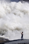
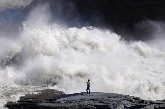
In a land of superlatives it's hard to pick out a favorite. Arguably, the most iconic emblem of Nahanni is Virginia Falls, a chunk of raging froth and foam that's twice the height of Niagara. Ted flies over the falls twice so that they can be viewed from both sides of the plane, then circles back upstream for a smooth landing on the Nahanni River. He leads us ashore on an easy hike to the raging Sluice Box Rapids. Here, in plain view of Sunblood Mountain, the Nahanni River roars with momentum, then splits around a massive tower of limestone known as Mason's rock before it plunges 294 feet into the river below. We skirt along above the river through underbrush to a cliff-top spot overlooking the falls. Tiny mountain orchids, Alberta roses and the Northwest Territories' floral emblem, the delicate cream-coloured mountain avens, line the path. Muskeg, which on first glance seems as unremarkable as cabbage, is on closer inspection a wonderwork of colorful lichens, squishy mosses and intricately detailed flowers.
The Northwest Territories cover an immense expanse— from the 60th parallel almost to the North Pole. With 11 official languages, nine of them Aboriginal, and fewer than 42,000 people scattered over an area almost the size of France, the joke is that there are more languages in the NWT than roads.
Remarkably, the first road to reach Canada's Arctic coast opened only a few months ago, in November of 2017. Called the Inuvik-Tuktoyaktuk Highway (ITH), it connects Inuvik on the Mackenzie Delta and Tuktoyatuk on the Arctic Ocean. The ITH is actually an 85-mile extension of the storied Dempster Highway, the dusty, gravel, 500-mile throughway that starts near Dawson City, Yukon, and ends in Inuvik, NWT. It is the only Canadian highway that crosses the Arctic Circle, which means that travel to Inuvik and among the NWT's northern communities is mainly by air year round or on ice roads (plowed frozen lakes and rivers) in winter.
Inuvik is Canada's northernmost town, purpose-built in the 1950s to replace Aklavik as the administrative center for the western Arctic. Like Fort Simpson, Inuvik is also a gateway to spectacular landscapes. Situated on the shores of the mighty Mackenzie River's East Channel, Inuvik is the springboard for airplane and boat tours of the complex Mackenzie Delta. The Mackenzie is Canada's longest river but by the time it reaches Inuvik it's no longer a single artery but a vast and crazy web of watery tentacles and bewildering channels. One needs a good guide to navigate through the beautiful chaos or risk erring into false channels and dead ends.
Kylik Kisoun Taylor, founder and owner of Tundra North Tours is one of the best. Of European and Aboriginal ancestry, Kylik grew up in the province of Ontario but reconnected with his Gwich'in and Inuvialuit roots when he returned to the NWT at the age of 16. He quickly developed a love for the Arctic and a passion to share its untouched wilderness with the world. He began by taking visitors on boat tours to out-of-the-way places and founding his own company, Up North Tours, at the age of 20. He later expanded and rebranded the company as Tundra North Tours and now offers a range of adventures that include boat tours, flight-seeing tours, ice road trips and reindeer herding. A tireless and passionate promoter of northern tourism, he is Inuvik's pride and joy, a self-taught go-to man who abides by Richard Branson's modus operandi: "If someone offers you an amazing opportunity and you don't know how to do it, take the opportunity to learn how to do it."
When the town needed someone to build an igloo for an event, Kylik volunteered. He wasn't concerned about the fact that he had no idea how and no one to ask. "No one builds igloos any more. I researched how... then did it. Now I am the town's igloo guy and I build one every year." Although he credits his grandfather and the elders for teaching him much about his culture, he still gets a chuckle out of people who ask him if he learned igloo-building from his ancestors. "I guess the truth just isn't as good a story," he says.
Kylik was full of good stories. While boating us through the winding channels of the Mackenzie Delta he regaled us with fascinating tidbits of personal, historical and cultural information, all the while keeping a deft eye out for wildlife. Amid explanations of permafrost, the collapse of the oil industry, or the migration paths of caribou, he'd suddenly break into "Look, over there, a moose!" then carry on with his story. All the while we skimmed past changing backdrops and foregrounds. Grassy marshes, gave way to forested shores, hilly islands, then sandy flats. We saw half-naked trees along the shores, their bark ripped off by ice from the river.
At Reindeer Station we disembarked to walk among the abandoned cabins of a failed mid-century government project. Kylik knowledgeably provided the backstory. At Burial Island, he switched to lore as he told of how the island got its name, while we watched peregrine falcons stoop-diving the cliff swallows that roost in the cliffside.
As we neared the Arctic Ocean, where we were to continue the journey on to Tuktoyaktuk, the wind picked up and riffled the water. It was a harbinger that the Arctic Ocean would be rough—possibly dangerously rough. Kylik made the difficult decision to turn the boat back to Inuvik and fly us to Tuk.
From the air the town of Inuvik came into amazingly sharp focus as the pilot circled it low—twice—so that passengers on both sides of the plane received equal viewing opportunity. Dominating the town, the white silver-domed Igloo Church looked even more striking from the air than from the ground. Other iconic buildings fell under bird's eye view: the museum-like Western Arctic Regional Visitor Center, the Ingamo Hall Friendship Centre, and the humble Midnight Sun Mosque, reputedly the northernmost mosque in the world. The locals affectionately call it the Little Mosque on the Tundra.
But if the town looked crisp, the sights we had stopped at earlier with Kylik stood almost unrecognizable from the air: Reindeer Station gained amazing framework seen tucked into a forested hillside. And the delta, that fascinating maze of lakes and streams and islands, swirled like polished malachite in dizzying patterns. Gradually the lakes and ponds expanded, their deep blue and brown hues fading until they merged with the pale blue Arctic Ocean. The Mackenzie River basin drains about 20 per cent of Canada, discharging about 78 cubic miles of water a year into the Arctic Ocean. The sheer amount of fresh river water coupled with thawing icebergs and low evaporation gives it the lowest salinity of all the oceans in the world.
As we approached Tuktoyaktuk we could see the remnants of the Cold War's DEW (Distant Early Warning) Line in the form of three giant golf balls towering at the edge of the ocean. Pingos—conical hills pushed up by ice under tundra—contrasted with the colorful prefab homes and warehouses that dotted the sea-soaked peninsula. Just a slight rise in the ocean level and the place would disappear.
John, our insightful guide, met us at the airport and plied us with local lore and history as he showed us Tuktoyaktuk's most distinguishing landmarks: fish-drying installations along Tuk Harbor, a 60s-era ice house, sod houses, the Trans-Canada Trail monument and the historic schooner beside the Catholic Mission.
There was one last thing we wanted to do before catching a return flight to Inuvik: dip our toes into the Arctic Ocean. As expected, it felt cold… but not nearly as cold as when we plunged in whole-hog. The experience is best summed up as b-r-r-r-r…. crazily worth it for the certificate and the bucket list checkmark.
Flying back to Inuvik I again looked down at the blobs of lakes and islands tossed on the tundra like jewels on a carpet. There was something magical and raw and authentic in the immenseness. It turns out that the road less travelled isn't a road at all. It's not even on the map. It's the vast and open sky.
- Apartments, Housing, and Real Estate
- Automotive Sales & Leasing - Cars, SUVs & Trucks
- Clothing & Apparel
- Communications & Technology
- Concierge Services
- Contracting
- Dining & Entertainment
- Education
- Event Planning Services
- Financial Services
- Health & Beauty
- Home Furnishings
- Hotels & Accommodations
- Insurance
- Medical & Dental Services
- Office Services
- Property Management
- Security Services
- Shipping & Moving Services
- Specialty Services
- Travel & Transportation

info@diplomaticconnections.com
It is strictly prohibited and illegal to download, replicate, retransmit, reproduce, or otherwise use any items whatsoever on this website.